Monthly Observations
October 2023
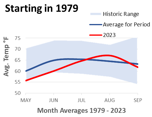
How’s the Weather - A Matter of Perspective On September 7th the World Meteorological Organization (WMO) announced that the previous month was the hottest August ever recorded. It was also the second hottest month measured by the WMO, behind only July 2023. Their announcement included the observation that the world’s oceans have reached their highest temperatures ever recorded. Locally, the story appears less extreme. August temperatures were above average, but as anyone in the North Coast wine business can affirm, the grape crop is well behind its normal harvest schedule. Obviously, there are more factors than simple temperature levels that determine grape maturity, but a comparison of average temperatures shows that our August heat was accompanied by abnormally low temperatures in May and June. Local data is public information drawn from the National Weather Service. The sample is small in size and personal in location. I entered the wine business in January 1979 and have maintained residence in Sonoma County ever since. My personal recollection of “normal” weather is drawn from local experience within the framework of grape development. I regularly consult the national weather station at the Sonoma County Airport to quantify that experience. That is the source for this comparison of average temperatures by month. The period of study was May through September and the years selected were 1979 through 2023. Results show that this year’s May and June reported two of the coolest month averages tracked since 1979. Mean temperatures rose to the historic average in July, above average in August and dipped below average in September. As we start October, the majority of Sonoma County’s grapes are still in the field. With a reasonably warm and dry October, the harvest of 2023 will hopefully reach a successful albeit hurried conclusion.
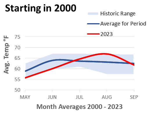
Taken as a 150-day group, the average temperature was 61.91 °F for the period May through September. The mean temperature in 2023 is –2.7% lower than the average seen since 1979. Reviewing the average 150-day observations by year indicates that most of the extreme results appeared prior to the year 2000. The comparison of variances between time periods presents a significant difference that is unlikely due to chance. It is not clear if the difference is due to new analytical conditions, statistical adjustments, or changes in weather patterns. Regardless of the cause, temperature data reveals two different views of weather patterns depending on the start date. From 1979 the average 150-day temperature shows a reduction in variance along a descending trend line with a slope of -4.4%. If looking at the 150-day temperature record starting in the year 2000, you see a slightly ascending trend line with a slope of 2.2%. This is where perspective comes into play. I cannot claim to be a great conversationalist, and many of my social encounters include some mention of “what do you think of this weather?”. Fellow boomers usually put today’s weather into perspective with examples of similar or more extreme experiences from the past. Younger people, who may have become interested in local weather after the year 2000, often express a perspective resigned to inevitable tribulations. Rather than attributing these differences to generational foibles, they may better be explained by the chronology of personal observations. From 1979 to today, this year’s season is comfortably bracketed within the historic range. Starting the clock in 2000 shows this year bouncing off the edges of narrow historical weather boundaries.
 
P Weber 10/2/23
|